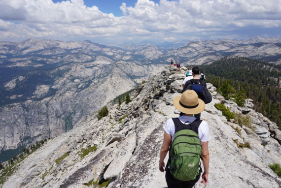
YOSEMITE NATIONAL PARK — The last 200 yards to the 9,926 foot summit of Clouds Rest overlooking Yosemite Valley is what the French call an arete.
If you are even just slightly squeamish with heights you’d call it insane.
Arete is the name geologists have bestowed on a narrow ridge of rock that separates two glacier carved valleys.
After glaciers create them, the free-thaw weathering process sharpens them hence the name “razor’ many have given the last 200 yards you must traverse to reach the summit.
I hiked it the first time 11 years ago.
I’m planning my third trip next summer when the Tioga Road is cleared of snow, given the trailhead at the western end of Sunrise Lake lops off four miles compared to the route up from Yosemite Valley.
The Tioga Road starting point makes it a 14.5 mile round trip with a 1,775-foot elevation gain as opposed to a net elevation gain of 6,000 feet over 18 miles from Yosemite Valley.
The shorter route can be a bit mundane as it is more forest although there is Yosemite eye candy until you take the cutoff to head to the razor.
The trailhead at Sunrise Lakes is at 8,150 feet.
You will need mosquito repellent, as the first half mile crosses streams and passes small lakes.
The toughest part of the hike is about 1.5 miles into it where a series of switchbacks rapidly pile up 1,000 of the 1,775 net feet of elevation gain that you’ll accumulate over the course of the hike.
Clouds Rest is where I understood what is meant by the expression “life is taken best in a bunch of small steps.”
Why that’s the case will become clear when you’re thinking about every step you’re taking as you gingerly cross a rocky spine that widens at the most to 20 feet over the course of 300 yards.
Keep in mind you’re 9,900 feet up dealing with granite boulders on a razor thin spine with a drop-off on one side of 5,000 feet with another 2,000 feet or so on the other side.
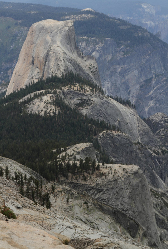
I became obsessed about hiking Clouds Rest after paying $50 for a framed photograph taken from its summit looking to the south toward Half Dome on the other side of Tenya Canyon.
What cemented it was looking at several YouTube videos taken by other hikers with helmet cams as they made their way across the razor.
Just looking at them got my heart pounding.
My first hike of Clouds Rest was arranged so I could take my then 15-year-old nephew Garrison MacQueen on the hike that I sandwiched between a hike up Mt. Whitney the day before and then the tourist magnet that is known as the Mist Trail the next day.
Then about two weeks before the trip, I made a mistake.
I looked at a YouTube video taken with a video cam by a hiker covering the treacherous spine, It was 21 seconds long but long enough to elevate my heart rate as well as question my sanity.
It didn’t help that Internet postings of the hike described the narrowest part as being between six and 10 feet.
That, I discovered, was somewhat misleading but then if you deviate much from that area you would find yourself in a tight area between the ridge and a sheer drop-off.
Nor was it reassuring that some postings focused on a 53-year-old woman who went over the edge in 2009, bounced a couple of times, and came to rest 80 feet below on a ledge just short of a long drop-off.
After hiking just over 7 miles from the Sunrise Lakes Trailhead we arrived at “The Razor” that stretches for some 1,000 feet before you reach the summit that is a generous 50 feet wide.
Garrison was following me, making it all that more important to make sure I selected the right steps across the uneven granite boulders across the ridge that often required a careful two to three feet up.
It wouldn’t have been a good time to suddenly discover one of us had vertigo.
There were two spots that sent off a “this-isn’t-a-good-idea” alarm in my head.
Before me was a granite rock with a four-foot wide surface that was about a three-foot step up. There was probably a good two feet on other side of it wouldn’t do that much good if you lost your footing stepping up.
For whatever reason, I remembered advice given to me from a judge from Exeter while we were bicycling up an 18 percent grade on my first trip to Death Valley 26 years prior as part of an optional route on a Backroads Touring excursion.
Instead of keeping an eye on the crest, he told me to focus down on the ground and gain strength in covering short distances while periodically glancing up quickly to make sure you were still on course. His theory was simple.
Herculean tasks become do-able if you break them down into small steps. It helps build confidence and fights becoming disheartened to the point you give up on the journey.
Even though “The Razor” was somewhat dangerous to cross — I wouldn’t do it in high winds nor in wet weather — it didn’t warrant a panic attack.
Once at the top, the views were incredible especially the smile on Garrison’s face.
Garrison was convinced I’m crazy. He told my sister my idea of resting while hiking uphill was walking instead of running. While that is a bit of an exaggeration, what isn’t is the fact I gained strength from Garrison.
The day before at just below 12,000 feet on Mt. Whitney Garrison developed attitude sickness. He had been moving at a steady pace before it hit. He started getting sick to his stomach and got a throbbing headache. I suggested we go back. He wanted to keep going. I figured as long as we took it easy we could see what happened. The time between stops kept getting shorter and shorter. That said, Garrison’s smile never disappeared.
Finally, it was clear that going on would just make it worse and would make whatever additional net elevation gain we managed to put behind up toward the 14,505-foot summit not just painful but problematic if it created lasting problems impacting our descent.
Turning around was a blessing. On my two previous trips up Mt. Whitney, I didn’t take time to explore the scenery I passed. It is a demanding 22-mile day hike that you start an hour or so after midnight so you can summit early enough to beat the darkness on the way back.

On that trip, though, we had time to take in a lush sliver of an alpine meadow at just below 12,000 feet, talk about life while watching fish jump out of the water at Mirror Lake.
We stopped for 10 minutes at one point of the descent around 8,000 feet and debate whether five birds that were making cooing sounds some six feet in front of us on rocks were some type of quail since all we saw them do was hop around.
And although I was disappointed for Garrison that we didn’t summit (he did on a subsequent trip), I can assure you his company and unbridled enthusiasm about what we were able to see as far as we got made it an even more rewarding experience for me than the first time I actually did make it to the top.
The view from the summit is nothing but miles of vastness defined by endless granite. In terms of sheer wonder it can’t compare with seeing the world through the eyes of a 15-year-old.
A 15-year-old who, by the way, was downright fearless when we talked about hiking Clouds Rest and saw not an exhausting hike but an amazing adventure.
And no matter how hard or tired he got, he never stopped smiling.
The journey to Clouds Rest has its share of sights.
There are numerous wildflowers, a lake or two, meadows, and jaw-dropping views.
The trail has several forks. All you have to do is stay to the right (basically straight). There is one confusing fork that doesn’t have Clouds Rest punched out on any of the metal trail signs although someone had thoughtfully scratched “Clouds Rest” on the metal.
The six to eight hour round-trip to the top is worth it.
It includes an absolutely stunning view of Yosemite Valley, a unique look at Half Dome and the ability to see just about every major point of interest in Yosemite that you know of and many others you’ve never seen before.
Bring a pair of binoculars and you can watch hikers trudge up the Half Dome cables while you rest atop Clouds Rest.
And perhaps the best part is you can take in almost the entire Yosemite Valley without seeing a car or a horde of people.


